Monthly Archives: April 2017

Day 10 – Glendambo to Coober Pedy

We woke to another lovely day – cold first thing but the sun soon warms things up.  There seem to be a lot of very small birds here and they sound very happy.  Before we left for the day’s journey I got out the tyre compressor and gave the tyres a bit of a top up – we constantly monitor our tyres with a TPMS and the tyres had lost a little pressure so it seemed a worthwhile effort to get them all a bit more consistent.

Once on the road and heading North-West pretty much the first thing we encountered on the highway was a “Prohibited Area” sign reminding us that we are in the Woomera Prohibited Area.  Honestly we don’t intend straying off the main highway at all!

We’re driving through the Woomera Prohibited Zone

Our stop for morning coffee was at the Bon Bon Rest Area (433) – this is a “super” rest area and there aren’t too many like this one!  Not only does it have sheltered chairs and tables, it has toilets, water for birds and pets, and an emergency telephone.  Most rest areas are full of puddles and you’re lucky if there is a table, so this was a good find.  Apart from occasional traffic noise, it was almost silent and amazingly peaceful.  It would be a very good contender for an overnight stay.

Bon Bon “Super” Rest Area

Continuing along A87 we soon came to a spot where the highway doubles as a RFDS landing strip – the road is wider and there are various markings, plus a side area where presumably road vehicles can wait for the airplane to arrive. You don’t see these every day!

Emergency RFDS Landing Strip

We were soon confronted by a pilot vehicle warning of an approaching ‘oversize vehicle’.  It was oversize too – in fact it was an army tank!  And a minute later came another one.

Oversize Load

Lunch stop was at the Ingomar Rest Area (435) – not as flash as the previous one but it was a nice open flat spot with some shelter.  Disappointingly there was a lot of rubbish around the place despite there being ample rubbish bins available.

Rest Area for lunch

Today has mostly been a drive along flat and arid plains, with occasional variations in the scenery. The road surface has, overall, been excellent, which has made the driving easier.  Despite being in a Prohibited Area there are a number of pastoral stations operating here and there are various signs along the highway advising station names plus the fact that most of the area is unfenced and that there may be livestock on the road.  Fortunately we didn’t meet anything on the road, but we didn’t see any live stock in the paddocks, or very little road kill on the side of the road.

Watch out for animals on the road!

At various places we saw small buildings and large aerial towers obviously powered by solar – makes total sense!

There were also various excavations and roads to mines and opal diggings.  In particular there seemed to be a particular patch of opal diggings about 40 kilometres from Coober Pedy.

Excavations, opals diggings, underground houses

Some interesting signs welcomed us to Coober Pedy and we couldn’t resist taking Bertha’s photo under the welcoming opal “blower” truck on the outskirts of town (it has just been refurbished as hasn’t been sign-written as yet).

Welcome to Coober Pedy

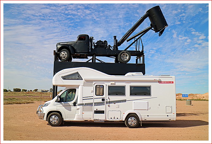
Bertha at Coober Pedy

Before going to the caravan park we made an obligatory stop at the town “dump point” for obvious reasons.  At the dump point there are also some water bowsers where you can fill up your water tanks for a fee.  One thing you learn about travelling in remote areas is that you need to keep your fresh water tank full and your grey water tank and your toilet cassette empty.  Places to fill and/or empty can be hard to find, so this place in Coober Pedy is a godsend to travellers.

Water bowser at Coober Pedy

We then made our way to the Opal Inn Caravan Park, and the first thing we did was to fill up our water tank – it was cheaper here than in the council facility.  The first site allocated by the caravan park didn’t suit so we found another and did a decent set-up with power, sullage (onto the garden) and put out the awning.  There is no water to individual sites and as a further reflection of the scarcity of water, the showers cost 20c for 4 minutes.

After setting up Bertha we went for a quick walk into town, but late on a Saturday afternoon isn’t ideal so we headed back to Bertha to relax.  We went to the Opal Inn Motel Bistro for dinner tonight and had wonderful vegetarian pizza and some delicious deserts (we’ll go for a long walk tomorrow to work it off!).

Bertha comfortable at Coober Pedy

Once again, nature treated us to a brilliant sun-set.  Hopefully you can make out the silhouette of a miner in the photo.

Sunset at Coober Pedy

We’ll be in Coober Pedy for at least a couple of days, so we’ll update this blog once we have more to report.

Categories: 2017 Up The Centre Adventure | Tags:

Day 9 – Andamooka to Glendambo

We both slept like logs last night – the diesel heater worked a treat and we were snug as a bug in a rug!  It was crisp but bright and sunny this morning and even at 7 am the solar panels were doing a great job replenishing Bertha’s batteries.

The local community certainly looks after this park and a cleaner came bright and early.  We noticed that even a few locals came down and had a coin in the slot shower!

After breakfast and a quick pack-up we headed off into Andamooka to explore.  First stop was a display of mining equipment from the 1950s and 1960s – very inventive and creative people live here.

Display of opal mining machinery at Andamooka

There is a nice park and a wide variety of houses ranging from tin sheds, rock and stone buildings, to very modern.  Some are no longer occupied but are left in place as a reminder of how things used to be.  The mullock heaps are everywhere.

Scenes around Andamooka

Andamooka is deceptively large and quite spread out, but the bitumen only goes up the main street so we had some limits as to where we were prepared to go in Bertha.  The mud on the main street and the tyre tracks down most of the other streets suggest that Andamooka has very recently had a LOT of rain.

Heritage Museum

There is a “commercial” strip with shops, cafes, a Post Office and the Bottle House with a very interesting underground display, and a very historic museum set-up.

Shops and bottle house

Views of the shopping area

From Andamooka we drove the short distance to Olympic Dam.  BHP operate here on a large scale and mine copper and uranium, and maybe some other minerals as well.  BHP have a large “Olympic Village” with rows and rows of accommodation huts for their workers, plus shops and other facilities. Even the car park is huge.

Entry to BHP complex

BHP’s Olympic Village

Massive water tanks

There are many sporting clubs and facilities in town, although football is currently not a very viable option.

Football not currently an option

There are many signs around town indicating that BHP is engaged in an “Arid Lands Revegetation Program” and it has to be said that this is a very well maintained place.

BHP has an Arid Lands Revegetation Program

A short drive from Olympic Dam found us in Roxby Downs, which was a town created in 1982 for mine workers and their families.  We were surprised to find a well maintained modern town with established education complexes and other community facilities.  Even as tourists you can feel a strong sense of community here.  Roxby Downs is apparently connected to the SA power grid, which probably explains the power lines that we noted yesterday.

Roxby Downs – Suburbia in remote SA

From Roxby Downs we continued heading South along the fence for the Woomera Prohibited Area until we reached the Woomera township.  There is caravan-park here and several double storey blocks of units.  We parked Bertha in the allocated RV parking area and went for a good long walk around town.

Oops – don’t go there!

Woomera was created in 1947 as a joint venture between Australia and Great Britain, and is billed as “the World’s Largest Test and Evaluation site”. As might be expected, displays of rockets and missiles are everywhere, mostly with explanatory plaques.

Welcome to Woomera

Plenty of missile displays around town

There are shops, a theatre complex, a heritage centre which really has to be seen to be believed, a bowling alley, a medical centre, school, and more.

Decent shopping facilities

Theatre complex

Heritage Centre

Some features, including the museum, weren’t open today, even though we are currently experiencing the SA school holidays.  As interesting as this place is, it does seem a bit “tired”, and it appears that the hospital has recently been decommissioned.

After having our lunch in Bertha at Woomera, we continued South to Pimba and Spud’s Roadhouse where we topped up the diesel.  I paid $1.599 per litre!

We then headed North-West on A87 towards Coober Pedy.  A family of emus looked up calmly as we went passed.

More emus

Along the way we stopped for a photo opportunity from the other end of Island Lagoon that we saw yesterday.  It was amazing and it was quite surprising to see how far back the water had receded from recent high water marks caused by very recent rain downpours.

Island Lagoon from the other side

After kilometres of saltbush we were next surprised to pass by Eucolo Creek which seemed to be several kilometres wide and still containing heaps of water.  Again, it was easy to see high water lines and gauge how much this creek had subsided.   There really must have been some absolutely tremendous downpours in this area not very long ago.  It does seem a pity that all that water can’t be better managed to cater for dry periods at other times of the year.

Eucolo Creek – waters receding

Next we came to the Lake Hart Lookout.  It was a beautiful place and obviously several caravans and motorhomes were planning on staying for the night.  We were tempted ourselves.  What makes this place so nice is that not only can you look over Lake Hart and admire the view, you can actually walk down to the lake.  Several people even appeared to be either wading or swimming!

Lake Hart Lookout

Another 70 kilometres or so along the highway and we came to tonight’s destination at Glendambo Outback Resort.  Glendambo itself appears to consist of a Shell Roadhouse, a BP Roadhouse, and the Glendambo Hotel-Motel.  Not bad a place this size having two servos!  The “Outback Resort” – by which they mean caravan-park – is located behind the hotel.  We weren’t really expecting a resort, but this place is a disappointment.  It doesn’t have all the promised facilities – we have power but no water – the amenities are in sad disrepair, there’s no camp kitchen, etc.  In fact the only good thing about this place is the location – it is a very convenient near mid-point between Port Augusta and Coober Pedy.  Having said all that, it’s OK and we’ll stop here tonight and head off tomorrow. We were relying on being able to top up our water here before reaching Coober Pedy so we’ll just have to be a bit more careful with our water usage from now on.

Glendambo Outback Resort

Sunset was pretty spectacular!

Spectacular sunset at Glendambo

We have thoroughly enjoyed our outback detour to Andamooka from the direct route from Port Augusta to Darwin and we’re glad that we made the effort.  The outback can be so different yet so calming and relaxing.

Watch out Coober Pedy – we arrive tomorrow!

Categories: 2017 Up The Centre Adventure | Tags: , , , ,

Day 8 – Port Augusta to Andamooka

Today was a very exciting day as from now on we will be in unfamiliar territory!

We woke up to another very cold morning but the sun came out and wow, what a lovely day!

After a farewell chat with our neighbours, packing up and refuelling, we were off – heading North along the Stuart Highway, a road we haven’t travelled on before.  Not far out of Port Augusta and we were in saltbush country – that is all there was to see.  It was a great road and ideal driving weather, but the scenery was a little boring.  There were some large road trains occasionally, a few sheep grazing here and there, and cattle grids to keep us awake.

View just after we turned onto Stuart Highway at Port Augusta

Our first stop for a coffee was at Ranges View Rest Area (SA418) where we took a few photos of the scenery.

Views from Range View Rest Area

As we continued North, the scenery changed and then changed again – it wasn’t boring any more but continually changing from low saltbush scrub to more bushy scrub, to orange sand dunes to rocky patches, and even what may have been lakes.  Although on the surface things looked pretty dry, the edges of the road and the paddocks were actually that lovely red sticky mud that all travellers love to hate.

Water pipe and light-poles always seem to follow the road.

Views along the way showing different vegetation and conditions

At one stage we were passed by a bunch of bikies, who we caught up with and were overtaken by several times during the day.

Bikies on the road – we saw them several times

Just for added interest, we drove over a very long train.

We drove over a very long train

Somewhere along the way we stopped at another un-named and unsigned roadside stop for a quick stretch of the legs and to take a few photos of views across to what we’re pretty sure is “Island Lagoon”.

Views of (we think) Island Lagoon

First multi-lingual road sign we’ve seen

We stopped for lunch at Spud’s Roadhouse at Pimba.  Very much a typical outback establishment, Spud’s serves fuel, food, alcohol, is a general store, offers accommodation and has pokies.  A great all-rounder.  It was cold and windy so we couldn’t resist a small bag of very fresh and tasty hot chips – we did have some healthy stuff for lunch too!  The roadhouse also offers free camping and there are clean toilets and showers available for a small fee.

Spud’s Roadhouse at Pimba

From Pimba we headed north through Woomera.  This is very much dry, arid country with red rocky soil.  With only low vegetation, the power pylons stand out against the sky.  We assume that they take power to Roxby Downs and Olympic Dam.

Pylons contrast with low scrub

Other than occasional road traffic there are virtually no signs of stock or wild-life, although we did see a family of emus.  There is also surprisingly little road kill, which is probably a good thing.

Family of emus

We arrived at Apoma Camping Ground at Andamooka.  This is an opal mining town near Roxby Downs. There are piles of mining waste everywhere, even around houses.

Views coming into Andamooka

Coming into Andamooka

Apoma is a very “outback” camp ground but does have good clean amenities including pay showers, BBQs, a playground and a dump-ezy dump-point.  There is no power or water, and no TV reception.  At the moment it also has lots of red mud, so we made sure that we stopped on high ground.  There were three vans here when we arrived and a group of three vans travelling together set up camp not long after and immediately commenced a noisy happy hour around a big fire.

Free Camp at Andamooka

Across the road from us is a “Public Noodling Area” where loads of rocks are dumped and the public has a chance to go through looking for the elusive opal.  The chap in one of the established vans here told us that he has been coming here for years and has made some quite good finds.

We were quite weary after arriving here so we settled inside in Bertha as soon as it started getting cold.  The diesel heater might have to go on later.  Tomorrow we will do some exploring in town and then head back to the highway at Pimba to continue our trip North.

You can chart our travels today on this map

Categories: 2017 Up The Centre Adventure, Free Camping | Tags: ,

Day 7 – Burra to Port Augusta

WOW!! Winter must be here! The weather bureau forecast 4 degrees overnight, and this time it’s pretty certain they got it right!  Freezing this morning after a night with heavy rain and strong buffeting winds. At least it was nice and cosy in our Tardis.

We drove into Burra and parked in Ann’s favourite street outside her favourite stone houses before walking from one end of the shopping centre to the other.  We stopped for delicious coffee at Burra Fresh then visited Coopers Butchers for some of their award winning saltbush lamb sausages, as recommended by our friend PK.  We also bought some lamb back-strap and some other meat – if we’re going to eat dead animal we’re going to eat tasty dead animal!  We also stopped at the bakery for some fresh bread and at the IGA supermarket for milk, water, fruit and vegetables.  Now we have fully restocked after our quarantine inspection!

Views of Burra

Views of Burra

After making our contribution to the Burra economy we headed north along the Barrier Highway.  It wasn’t long before we were stunned to see a wind farm of 35 to 40 wind turbines, but only 2 or 3 were actually turning and generating electricity!  And it was a very windy day!  Doesn’t say much for being able to rely on wind power for energy production that’s for sure.

Wind Turbines not generating electricity

Hallett was our next stop to check out a potential free camp at the recreation reserve and on the way we spotted the very interestingly named Wildongoleechie Hotel.

Wildongoleechie Hotel in Hallett

Continuing along the highway toward Peterborough we couldn’t help but notice how dry the landscape was and that many creeks and dams still look empty – we assume that the farmers must be enjoying the recent rain!

Dry landscape on the way to Peterborough

As we drove into Peterborough we noticed that the road was quite wet and once we parked the wind and rain started again.  We have stayed in Peterborough a few times and decided to just have a quick lunch in Bertha and watch life in the main street.

Welcome signs indicates that Peterborough is a rail town!

Refreshed, we headed for Port Augusta in sunshine but it didn’t last very long.  As we approached Orroroo we could see the rain ahead of us and we did end up driving in and out of a rain cloud.

We drove through a rain cloud

Views of Orroroo

On the road to Wilmington

We continued through Orroroo and Wilmington and then through the challenging Horrocks Pass, which we have been through several times.  Taking things easy and ignoring the lead foot behind us ensured that we negotiated this very steep section of road without incident – the photos don’t quite reflect exactly how steep this pass is.

Views of Horrocks Pass

From Horrocks Pass we simply stayed on the road into Port Augusta – although we have driven through Port Augusta several times we have never stayed here.  After bypassing the city centre and going over the bridges, we secured a nice site at the Port August Discovery Caravan Park.  Dinner tonight was somewhat predictable – delicious saltbush lamb sausages cooked on the BBQ!

Coming into Port Augusta

Tomorrow, from Port Augusta we will be heading further North, so we will make sure that tyres are pumped up, batteries are fully charged, water tanks are full, etc.

Categories: 2017 Up The Centre Adventure | Tags: ,

Day 6 – Paringa to Burra

Although it rained most of the night, we woke to a pleasant, if slightly chilly, morning.

We left the caravan park and joined the queue of traffic as we approached the Paringa Lifting Bridge. On checking the time it was close to 9.30am, so we suspect that the traffic hold-up was due to the bridge having been lifted to allow river traffic to go underneath.

Traffic delays at the Paringa Lifting Bridge

We bypassed the main part of Renmark as we had been there about 12 months ago.  Being a public holiday nothing much was open anyway.

Skirting Renmark

Further along the highway we went through the small town of Barmera and again, nothing much was happening. Just out of town, however, we found a great bakery which was open and we stopped there for morning coffee.

Barmera main street on ANZAC Day

Barmera coffee house

There was very little activity anywhere much, other than the occasional ANZAC Day celebrations at RSLs, etc.  We continued through to Waikerie, where we couldn’t find the bakery (say that sentence out aloud).

Waikerie

From Waikerie we headed along very quiet roads to the Historic Port town of Morgan where we caught the ferry across the mighty Murray River.  When we told our son Phil about this later he commented that Bertha had temporarily become a houseboat!

Views along the highway

Approaching the ferry at Morgan

On the ferry at Morgan

Once off the ferry we stopped for lunch at a great spot overlooking the river where there were BBQs, tables and seating for families, a boat ramp, all well occupied by families having a day together.  We could also hear some young men obviously enjoying liquid refreshments while listening to a football match somewhere nearby.

River views at Morgan

From Morgan we proceeded along the Goyder Highway through “saltbush lamb country” to the historic town of Burra, where we had a quick look around.

Saltbush lamb country

Views around Burra

From the town centre we then went to the historic copper mine just out of town and drove up a rather steep and winding road to the mine lookout.  The trip was worthwhile as the views of the mine and associated buildings were fantastic.

Views of the mine from the lookout

Views from the mine lookout

Views over Burra from the lookout

Turning around we could also see wind turbines along a line of hills.

Wind turbines in the distance

Heading back down the hill we drove the short distance to the Burra Showgrounds where Arty the friendly caretaker set us up on a powered site next to the Poultry and Pigeon Pavilion (no birds are present at the moment).

Burra Showgrounds

We will do more exploring in Burra tomorrow when the shops are open.

Categories: 2017 Up The Centre Adventure | Tags: ,

Days 4 & 5 – Enjoying Paringa

Sunday

It was definitely a day of rest today and we had nothing in particular planned.

We caught up on some housework, cleaning Bertha after driving through rain, and spent several hours just relaxing outside with our books.  Highlight of the day was lunch at the Paringa Pub.  When we arrived we were the only customers there but quite a number of other people did arrive a little later and we all had a great time.  Ann had the roast of the day, which was duck, and she enjoyed it very much.  I had a delicious home-made pasta and sauce.  Lunch was accompanied by a very nice drop (or two) of local Angove Merlot.

Paringa Pub

The weather forecast on the evening news didn’t look too good!

Monday

Today we had originally planned to catch the local Amazon Bus service to see some of the local sights but we both seem to be suffering from head colds and decided not to inflict ourselves on other bus passengers.  Besides, there is rain and possible thunderstorms forecast for some-time today so we decided that staying close to Bertha would probably be a better idea.

We did wander over to the Paringa Bakery & Café and thoroughly enjoyed our coffee and cake.  From there we went on a good walk around Paringa to check out some of the local attractions.

Paringa Bakery & Cafe

First stop was the famous Black Stump, which is actually just across the road from the Bakery.  There are apparently 11 Black Stumps around Australia and Paringa is very proud that theirs is the biggest.  It is 8 metres in diameter, weighs 8 tonnes and is an estimated 600 years old.  It was found some 50 kilometres away and has been in its current location since 1984.

The Paringa Black Stump

From the Black Stump we walked past the local Paringa Community Museum which house various local artifacts and farm machinery from the area.

We couldn’t exactly miss the Paringa Lifting Bridge.  The bridge was opened in 1927 and was one of the earliest bridges to span the Murray River.  Part of its significance is the section which can be raised to allow the passage of river boats.  The lifting span is still raised twice a day, depending on river traffic – bookings are required.

View of Paringa Lifting Bridge

Next to the bridge is a community park which is currently being upgraded.  There are sweeping lawns where several families were enjoying picnics.  There is a nice rotunda for a bit of shelter (not sure if a brass band ever plays there).  We noticed several canoes out on the river.  Looking along the river banks we could see the start of what we are pretty sure is the Renmark Big 4 caravan park.

Great park with rotunda and family picnics

Canoeing on the river

Walking back from the bridge and park we stopped at Cammies Antiques and Collectibles which had an amazing collection of old and interesting treasures – but we are past buying stuff like that anymore – interesting to look.

Cammees Antiques & Collectibles

From there we picked up some lunch supplies at the bakery and headed back to Bertha for lunch.

Just as we were finishing lunch outside we felt the first drops of what we thought was the approaching rain.  Shade cloth wall and awning were immediately packed up before they got wet and we retreated with chairs inside.  The rain only lasted 30 minutes and we’ve had only light sprinkles ever since

Rain and thunderstorms are still forecast for today.  Tomorrow’s weather looks a little better and we plan on heading off towards Port Augusta.

Categories: 2017 Up The Centre Adventure | Tags:

Day 3 – Red Cliffs to Paringa, SA

It was a little foggy as I watched the sunrise over the grape vines this morning.  Sorry – I forgot to mention yesterday that Red Cliffs is the start of the Mildura wine region and that there are vines immediately behind the caravan park.

Sunrise over the vines at Red Cliffs

The vines became even more prolific the closer we got to Mildura.  Interestingly many of the vines were covered – I assume to protect from cold mornings, etc.

Covered grape vines at Mildura

Red Cliffs is only 15 kilometres from Mildura so it wasn’t long before we had parked Bertha and gone for a stroll around town.  We enjoyed coffee and cake at Hudaks Bakery, a favourite place of ours and picked up some supplies in town before continuing on our travels.

Scenes at Mildura

From Mildura we left the Calder and changed to the A20 towards Renmark.  From vineyards growing very close in to town, the scenery soon changed to cropping country.

Leaving Mildura

We later passed what appeared to be large plantations of almonds.

Almond trees (we think)

In what seemed to be only a short time we arrived at Lake Cullulleraine which looked to be a nice place to stop for thermos coffee overlooking the lake.  We did take a wrong turn and ended up at a dirt road going into a farming property.

Wrong way!

We retraced our steps and found a more appropriate entrance to the lakeside, where we were greeted with green lawns, shade, and benches and seating.  There was a lone speed-boat out on the water scaring the fish.

Views of Lake Cullulleraine

Leaving Lake Cullulleraine the scenery changed again and we saw large areas of cultivated land showing orange against the stubble in nearby paddocks.

Cultivated land contrasted against crop stubble

We continued along the Sturt Highway across the South Australian border where we stopped for a “photo opportunity”.

Bertha at the border

Within a couple of kilometres we had to stop at the Yamba quarantine station where Bertha was searched quite thoroughly for contraband fresh fruit and vegetables, plants and grape vines.  We were clean and left with a clean bill of health, unlike a couple of guys in very muddy off-road trucks who had bags and bags of fruit and vegies confiscated.  At least they were good natured about it and didn’t kick up a fuss.

Welcome to SA at Yamba quarantine stop

A few kilometres up the highway we stopped at Paringa Caravan Park, where we have booked in for a couple of nights “R & R”.  We set up Bertha with awning and shade wall, and I even changed into shorts.

Happy campers at Paringa

This is a small family run park where they really seem to care about their customers – we were given discount vouchers for the Paringa Pub and a heap of tourist information.  Paringa is a small town about 4 kms East of Renmark and we are very interested in catching a local shuttle bus which will take us to many interesting places in the Paringa/Renmark area.

We will report back in due course.

It was a glorious day today and we hope that this weather continues.

Categories: 2017 Up The Centre Adventure | Tags:

Day 2 – Charlton to Red Cliffs

We had heavy relentless rain all last night.  However, the skies cleared and we checked the weather forecast, and decided that if we headed generally North-West we should avoid most of the bad weather.

Leaving The Travellers’ Rest it was very obvious that the rain had left its mark.  We’re sure that we could see that the water level in the river had risen.

Water at The Travellers’ Rest

First stop was at Wycheproof for a quick walk around town.  Immediately obvious is the single rail line through the middle of town!  We found a very nice bakery where we purchased some fresh bread, and right next door was a yard full of incredible scrap metal sculptures. The peppercorn trees throughout town are a great backdrop to the historic buildings.

Scenes around Wycheproof

From Wycheproof we continued along the Calder headed for Sea Lake, and experienced annoying drizzle on the windscreen.  Through Nullawil, one of many small grain towns, surface water along the sides of the road was notable.

Water by the side of the road

The skies cleared and the sun came out as we got closer to Culgoa, but there was still plenty of surface water in the paddocks.

Surface water in paddocks

Through Berriwillock and Boigbeat we actually saw some blue sky!

Berriwillock

Some blue sky at last

At Sea Lake we stopped and had a good walk around town.  It seemed much more alive than 2008 when we were last here.  Like many country towns there are active efforts by members of the community to add interest for visitors, such as murals, nice places to sit, and interesting, quirky shops.

Views around Sea Lake

From Sea Lake we travelled only a few kilometres to the observation platform at Lake Tyrrell, otherwise known as the Pink Lake.  Lake Tyrrell is the largest salt lake in Victoria and covers some 20,860 hectares.  It wasn’t pink today unfortunately, but there were still some fantastic views over the Lake.  After photos and a chat with some other visitors, we settled down for a gourmet lunch in Bertha (I’m not kidding – smoked salmon and capers with herb cheese on wonderfully fresh bread!).

Views at Lake Tyrrell – The Pink Lake

Back of the highway, near Nandaly we were surprised to be overtaken by a pilot vehicle for an Oversize Load.

Pilot Vehicle

A quick look in the rear view mirror and we very quickly pulled off the highway at the next available spot.  Just as well as the truck certainly wasn’t going to slow down!

Oversize Load

We had only just pulled back onto the highway after the oversize truck when guess what approached very rapidly from the opposite direction?

Another Oversize Load

Continuing along the highway a roadside sign reminded us that we were soon to enter a quarantine area.  The skies were looking very grey and threatening so we decided to pull-over at the next roadside stop and eat our last fresh “Bushy Park” apple, rather than have to toss it in a bin further up the highway.  After enjoying our apple we pulled back onto the highway and the heavens opened up.  Bertha got very wet indeed and visibility was almost non-existent.

Pouring one minute

A couple of minutes later we drove through the rain clouds and sky was clear and blue.  Isn’t nature wonderful?

Clear the next

We went for a bit of a quick drive through Ouyen but didn’t stop for our usual walk-around town this time.  We had stayed at Ouyen some years ago and it didn’t seem to have changed much.

Another 80 kilometres or so up the highway we reached our destination for today of Red Cliffs Caravan Park.  This is quite a nice park and we had travelled far enough for one day of very mixed weather and driving conditions.

We’re looking forward to travelling through improved weather tomorrow.

Categories: 2017 Up The Centre Adventure | Tags:

Welcome to Shorty’s 2017 Up the Centre Adventure

Today was the first day of our 2017 “Up the Centre” Adventure.  Our planned ultimate destination is Darwin, and then we’ll see what happens from there.

Ready to Leave Home

With everything sorted at home, we headed off after peak hour along the Eastern Freeway and made our way to Lower Plenty, where, at the civilised time of 10:45 am I was breathalysed !  Passing with flying colours we made our way to the M80 Ringroad and then to the Calder Freeway.  We had a very good run and stopped for our first break at the Calder Park Service Centre, after only travelling for just over an hour.  Bertha was dwarfed by some of the other visitors in the carpark.

Calder Park

It was a great drive on the Calder but when we turned off the A790 just north of Ravenswood we really felt that we had left civilisation and were well and truly in the country.  By going this way through Marong we bypassed busy Bendigo.

Heading for Marong

Our next stop was the very pretty town of Bridgewater.  After purchasing some supplies at the Bakery, we drove around to the free camp at the recreation reserve where we stopped for lunch.

Bridgewater – nice old pub, post office and bakery

Refreshed, we headed north passing through Inglewood which was much bigger than Bridgewater and had some very interesting buildings.  We both commented that we would love to just spend some time cruising around this region and spending more time exploring each of the historic towns.

Views of Inglewood

As we approached Wedderburn we found ourselves in thick smoke.  We soon found the source of this unpleasant smoke – it seems that the farmers around here clear their paddocks by burning off.  Luckily for us it started to rain which immediately cleared the air and made life a bit more comfortable.

Burning off

The results of burning off paddocks

We soon arrived at Charlton, which is another attractive and historic small country town, with a great Caravan Park/Free Camp complex called The Travellers’ Rest.  Imagine, 3 nights on an unpowered site by the Avoca River for $10.00.  Powered and en-suite sites are also available.  After setting up we donned our rain-coats and had a good look around town.  The art-deco Rex Theatre is a standout.  Walking by the river we came across a statue of a swaggy carved in a tree trunk.

Charlton’s “Travellers’ Rest” area – right in the centre of town

Views along the river at Charlton – popular fishing spot.

The Rex Theatre and the carved Swaggy

Coats hung up to dry, we enjoyed a delicious meal inside Bertha while giant moths attacked the doors and windows.  Hilarious!!

What a great start to our adventure.  Now to work out where to go tomorrow!

Categories: 2017 Up The Centre Adventure | Tags:

Blog at WordPress.com.